:
Oleh Wilda Stiana, Kamis, 22 Desember 2022 | 14:57 WIB - Redaktur: Wilda Stiana - 4K
Jakarta, InfoPublik - All regions of Indonesia will potentially be hit by downpours to rainstorms during the 2022 Christmas and 2023 New Year, BMKG projected.
Based on the BMKG's impact-based forecasting information platform, several areas with potential alerts in the period 21-23 December 2022 are as follows:
1) Parts of Aceh,
2) Parts of North Sumatra,
3) Parts of Riau,
4) Parts of West Java,
5) Parts of Central Java,
6) Parts of East Java,
7) Parts of East Nusa Tenggara,
8) Parts of West Kalimantan,
9) Parts of East Kalimantan,
10) Parts of North Kalimantan,
11) Part of the Maluku region.
Based on impact-based forecasts, on 24 December, the BMKG said there were areas with potential alerts that needed to be watched out for, namely parts of Central Java, East Java, and South Sulawesi.
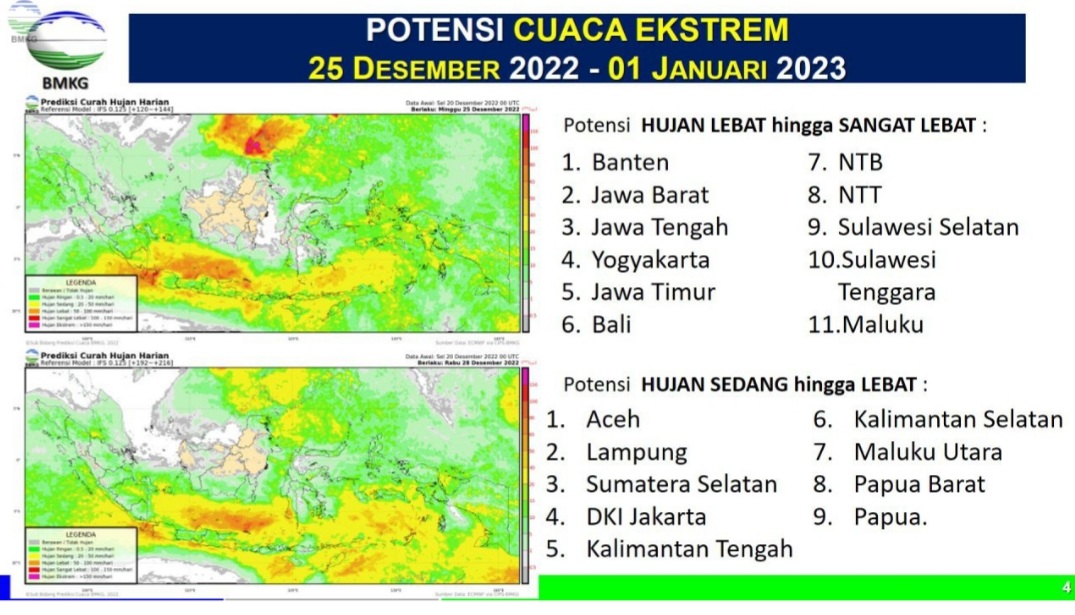
Several areas with the potential for significant intensity rain during the period 25 December 2022-1 January 2023 are as follows:
The potential for a downpour in the area:
1) Banten,
2) West Java,
3) Central Java,
4) Jogjakarta,
5) East Java,
6) Bali,
7) West Nusa Tenggara,
8) East Nusa Tenggara,
9) South Sulawesi,
10) Southeast Sulawesi, and
11) Maluku.
The areas that have the potential to experience moderate to heavy rain are as follows:
1) Aceh,
2) Lampung,
3) South Sumatra,
4) DKI Jakarta,
5) Central Kalimantan,
6) South Kalimantan,
7) North Maluku,
8) West Papua, and
9) Papua.
The head of the BMKG, Dwikorita Karnawati, said the increase in rainfall during the Christmas and New Year 2023 periods was due to several atmospheric dynamics. Among them, the increased activity of the Asian Monsoon can significantly increase the growth of rain clouds in the western, central, and southern parts of Indonesia.
In addition, the increasing intensity of the Asian cold rush can increase surface wind speeds in western and southern Indonesia and increase the potential for rain clouds around Kalimantan, Sumatra, Java, Bali, and Nusa Tenggara.
Other atmospheric dynamics are low-pressure center formation around the southern Indonesian waters, which can trigger the growth of massive convective clouds. It has the potential to cause high-intensity rain, increase surface wind speed, and increase the height of the surrounding waves.
"And fourthly, some atmospheric wave activity was observed, namely the Madden Julian Oscillation (MJO) phenomenon. It was formed simultaneously with the Kelvin and Equatorial Rossby waves. These conditions contributed significantly to increasing rainfall in several regions of Indonesia, especially in the central and eastern parts," she stated in her official statement on the BMKG.go.id website on Wednesday, 21 December.
Dwikorita said that apart from heavy rains, the complex dynamics of the atmosphere have the potential to cause high waves in Indonesian waters in the period 21-27 December 2022. The Indonesian waters that need to be paid attention to are:
1) Wave height category 2.5-4 meters:
The northern part of Malacca Strait, northern waters of Sabang, western waters of Aceh, western waters of Nias, Mentawai Islands waters, western waters of Enggano to Lampung, West Indian Ocean of Sumatra, Sunda Strait, southern waters of Java to NTB, South Indian Ocean of Banten, South Indian Ocean of Java East to NTB, Anambas-Natuna waters, Subi-Serasan waters, central and eastern Java Sea, central and eastern Sulawesi Sea, northern Sulawesi waters, western Sitaro Islands waters, Sangihe and Talaud Islands waters, North Pacific Ocean Halmahera to West Papua.
2) Wave height category 4-6 meters:
North Natuna Sea, South Indian Ocean West, and Central Java.
With this weather forecast, Dwikorita asked the public to continue to monitor weather forecast information and extreme weather early warnings from BMKG. According to him, the risk of hydrometeorological disasters such as floods, landslides, flash floods, strong winds, tornadoes, and high waves is considerable.
"The government and the community must increase awareness and preparedness in dealing with the risk of hydrometeorological disasters. Trim fragile tree branches and strengthen stands/poles to prevent them from collapsing in strong winds," he said.
The Regional Government, said Dwikorita, needs to intensify coordination, synergy, and communication between related parties for preparedness in anticipation of hydrometeorological disasters. In addition, the Regional Government must also ensure that the infrastructure capacity and water resources management system is ready to anticipate increased rainfall.
"It is also necessary to intensify information dissemination, education, and literacy on a more massive basis to increase the understanding and concern of the Regional Government, the community, and related parties in preventing/reducing the risk of hydrometeorological disasters," she added.
Meanwhile, continued Dwikorita, crossing transportation providers and the user community needs to increase vigilance to adapt and mitigate these conditions.
Photo: BMKG
Author: Dian Thenniarti
Editor: Untung S
Translator: Wilda Stiana